Trail Walking La Farlède - De La farlède vers le sommet du Mont Coudon, puis retour par le petit Coudon - Photo

De La farlède vers le sommet du Mont Coudon, puis retour par le petit Coudon

 FSantoni
FSantoni

User

© OpenStreetMap contributors
Length
Length
14.1 km
Max alt
Max alt
657 m
Uphill gradient
Uphill gradient
599 m
Km-Effort
Km-Effort  
22 km
Min alt
Min alt
90 m
Downhill gradient
Downhill gradient
600 m
Boucle
Boucle
Yes
Creation date :
2024-09-21 05:55:06.619
Updated on :
2024-09-21 15:56:31.371

(0 Reviews)

Walking
Walking
6h55
Difficulty : Very difficult

Scan this QR Code to open this trail in the SityTrail application

FREE GPS app for hiking

Logo SityTrail SityTrail

IGN / Geographical institutes

Download SityTrail from the App Store Download SityTrail from Google Play

Logo SityTrail SityTrail World

The world is yours!

Download SityTrail from the App Store Download SityTrail from Google Play Download SityTrail on Huawei AppGallery

About

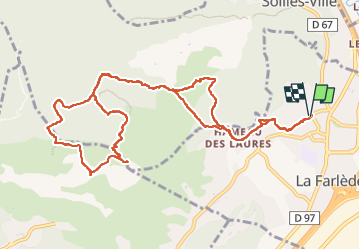
Trail Walking of 14.1 km to be discovered at Provence-Alpes-Côte d'Azur, Var, La Farlède. This trail is proposed by FSantoni.

Description

Une rando classique mais toujours aussi belle, par les paysages traversés et les panoramas offerts.
Excellent pour une reprise, avec cependant quelques portions bien pentues.

Elevation profile

Photos

Positioning

Country:
France
Region :
Provence-Alpes-Côte d'Azur
Department/Province :
Var
Municipality :
La Farlède
Location:
Unknown
Start:(UTM)
259359 ; 4783707 (32T) N.

Trails nearby

Trail Walking Solliès-Toucas - Valaury - Apier - Matheron - Photo
Walking
GUIDE
affinetataille

Walking

Medium
(1)
Solliès-Toucas, Provence-Alpes-Côte d'Azur, Var, France
13.1 km | 19.5 km-effort
5h 0min
Yes
Trail Walking La Valette-du-Var - SityTrail - Le tour du coudon - Photo
Walking
GUIDE
affinetataille

Walking

Difficult
(1)
La Valette-du-Var, Provence-Alpes-Côte d'Azur, Var, France
11.9 km | 19.4 km-effort
5h 0min
Yes
Trail Walking La Crau - fenouillet Daniel Louis - Photo
Walking
cdanielrando

Walking

Medium
(1)
La Crau, Provence-Alpes-Côte d'Azur, Var, France
18.1 km | 25 km-effort
4h 36min
Yes
Trail Walking La Crau - le fenouillet un après-midi d'automne  - Photo
Walking
le.noceur

Walking

Easy
(2)
La Crau, Provence-Alpes-Côte d'Azur, Var, France
7.6 km | 10.7 km-effort
1h 48min
Yes
Trail Walking Solliès-Toucas - couvent St Hubert Valaury - Photo
Walking
marchev

Walking

Very easy
(2)
Solliès-Toucas, Provence-Alpes-Côte d'Azur, Var, France
12.5 km | 19.2 km-effort
4h 30min
Yes
Trail Trail Solliès-Pont - Le Coudon  - Photo
Trail
GUIDE
nadd73

Trail

Difficult
Solliès-Pont, Provence-Alpes-Côte d'Azur, Var, France
22 km | 35 km-effort
3h 30min
Yes
Trail Trail La Crau - Le Fenouillet et château d' Hyères  - Photo
Trail
GUIDE
nadd73

Trail

Medium
La Crau, Provence-Alpes-Côte d'Azur, Var, France
13.1 km | 18.8 km-effort
2h 9min
No
Trail Walking La Crau - Fenouillet - Chateau de Hyères - retour par les vignes - Photo
Walking
GUIDE
affinetataille

Walking

Medium
(2)
La Crau, Provence-Alpes-Côte d'Azur, Var, France
14.1 km | 19.7 km-effort
5h 0min
Yes
Trail Walking Solliès-Ville - Domaine de la Castille-20-09-2024 - Photo
Walking
Christiancordin

Walking

Easy
Solliès-Ville, Provence-Alpes-Côte d'Azur, Var, France
6.3 km | 7 km-effort
1h 37min
Yes


Close
My subscriptions